
Magnitude 5.0 - MORO GULF, MINDANAO, PHILIPPINES
2010 August 24 20:48:04 UTC
Earthquake Details
- This event has been reviewed by a seismologist.
| Magnitude | 5.0 |
|---|---|
| Date-Time |
|
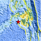
| Location | 6.743°N, 123.571°E |
| Depth | 593.8 km (369.0 miles) set by location program |
| Region | MORO GULF, MINDANAO, PHILIPPINES |
| Distances | 90 km (55 miles) SW of Cotabato, Mindanao, Philippines 120 km (75 miles) S of Pagadian, Mindanao, Philippines 165 km (105 miles) E of Zamboanga, Mindanao, Philippines 915 km (570 miles) SSE of MANILA, Philippines |
| Location Uncertainty | horizontal +/- 6.6 km (4.1 miles); depth fixed by location program |
| Parameters | NST= 80, Nph= 80, Dmin=224.8 km, Rmss=0.96 sec, Gp= 43°, M-type=body wave magnitude (Mb), Version=7 |
| Source |
|
| Event ID | us2010aibw |
- Did you feel it? Report shaking and damage at your location. You can also view a map displaying accumulated data from your report and others.

Earthquake Maps


Scientific & Technical Information
 Historic Moment Tensor Solutions
- Preliminary Earthquake Report
- U.S. Geological Survey, National Earthquake Information Center:
World Data Center for Seismology, Denver
