
 Feeds & Data
Magnitude 4.8 - STATE OF YAP, FED. STATES OF MICRONESIA
2009 April 30 01:58:42 UTC
Earthquake Details
| Magnitude | 4.8 |
|---|---|
| Date-Time |
|
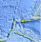
| Location | 11.002°N, 140.462°E |
| Depth | 45.9 km (28.5 miles) |
| Region | STATE OF YAP, FED. STATES OF MICRONESIA |
| Distances | 305 km (190 miles) ENE of Yap, Micronesia 540 km (335 miles) WSW of HAGATNA, Guam 620 km (385 miles) WSW of Rota, Northern Mariana Islands 1995 km (1240 miles) WNW of PALIKIR, Pohnpei, Micronesia |
| Location Uncertainty | horizontal +/- 10.5 km (6.5 miles); depth +/- 7.3 km (4.5 miles) |
| Parameters | NST= 37, Nph= 37, Dmin=558.3 km, Rmss=0.75 sec, Gp= 65°, M-type=body wave magnitude (Mb), Version=Q |
| Source |
|
| Event ID | us2009gbae |
- This event has been reviewed by a seismologist.
- Did you feel it? Report shaking and damage at your location. You can also view a map displaying accumulated data from your report and others.
Earthquake Maps


Scientific & Technical Information
 Historic Moment Tensor Solutions
- Preliminary Earthquake Report
- U.S. Geological Survey, National Earthquake Information Center:
World Data Center for Seismology, Denver
