
 Feeds & Data
Magnitude 4.8 - SOUTH OF SUMBAWA, INDONESIA
2009 April 29 21:31:25 UTC
Earthquake Details
| Magnitude | 4.8 |
|---|---|
| Date-Time |
|
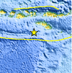
| Location | 10.613°S, 118.777°E |
| Depth | 56.1 km (34.9 miles) |
| Region | SOUTH OF SUMBAWA, INDONESIA |
| Distances | 240 km (150 miles) S of Raba, Sumbawa, Indonesia 320 km (200 miles) ESE of Mataram, Lombok, Indonesia 370 km (230 miles) WSW of Ende, Flores, Indonesia 1410 km (880 miles) ESE of JAKARTA, Java, Indonesia |
| Location Uncertainty | horizontal +/- 11.2 km (7.0 miles); depth +/- 10.8 km (6.7 miles) |
| Parameters | NST= 31, Nph= 31, Dmin=628.4 km, Rmss=0.96 sec, Gp= 79°, M-type=body wave magnitude (Mb), Version=Q |
| Source |
|
| Event ID | us2009gace |
- This event has been reviewed by a seismologist.
- Did you feel it? Report shaking and damage at your location. You can also view a map displaying accumulated data from your report and others.

Earthquake Maps


Scientific & Technical Information
 Historic Moment Tensor Solutions
- Preliminary Earthquake Report
- U.S. Geological Survey, National Earthquake Information Center:
World Data Center for Seismology, Denver
