
 Feeds & Data
Magnitude 4.9 - SOUTHERN SUMATRA, INDONESIA
2009 April 27 09:33:39 UTC
Earthquake Details
| Magnitude | 4.9 |
|---|---|
| Date-Time |
|
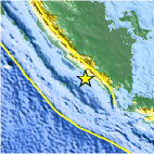
| Location | 5.123°S, 103.401°E |
| Depth | 35 km (21.7 miles) set by location program |
| Region | SOUTHERN SUMATRA, INDONESIA |
| Distances | 195 km (120 miles) SE of Bengkulu, Sumatra, Indonesia 210 km (130 miles) W of T.-Telukbetung, Sumatra, Indonesia 280 km (175 miles) SSW of Palembang, Sumatra, Indonesia 385 km (240 miles) WNW of JAKARTA, Java, Indonesia |
| Location Uncertainty | horizontal +/- 12.1 km (7.5 miles); depth fixed by location program |
| Parameters | NST= 54, Nph= 54, Dmin=>999 km, Rmss=1.06 sec, Gp= 86°, M-type=body wave magnitude (Mb), Version=7 |
| Source |
|
| Event ID | us2009fyas |
- This event has been reviewed by a seismologist.
- Did you feel it? Report shaking and damage at your location. You can also view a map displaying accumulated data from your report and others.

Earthquake Maps


Scientific & Technical Information
 Historic Moment Tensor Solutions
- Preliminary Earthquake Report
- U.S. Geological Survey, National Earthquake Information Center:
World Data Center for Seismology, Denver
