
 Feeds & Data
Magnitude 4.4 - HALMAHERA, INDONESIA
2009 April 25 18:41:07 UTC
Earthquake Details
| Magnitude | 4.4 |
|---|---|
| Date-Time |
|
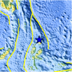
| Location | 2.571°N, 128.349°E |
| Depth | 171 km (106.3 miles) set by location program |
| Region | HALMAHERA, INDONESIA |
| Distances | 225 km (140 miles) NNE of Ternate, Moluccas, Indonesia 405 km (255 miles) ENE of Manado, Sulawesi, Indonesia 1560 km (970 miles) SSE of MANILA, Philippines 2580 km (1600 miles) ENE of JAKARTA, Java, Indonesia |
| Location Uncertainty | horizontal +/- 14.4 km (8.9 miles); depth fixed by location program |
| Parameters | NST= 20, Nph= 20, Dmin=>999 km, Rmss=0.86 sec, Gp=115°, M-type=body wave magnitude (Mb), Version=Q |
| Source |
|
| Event ID | us2009fwbm |
- This event has been reviewed by a seismologist.
- Did you feel it? Report shaking and damage at your location. You can also view a map displaying accumulated data from your report and others.

Earthquake Maps


Scientific & Technical Information
 Historic Moment Tensor Solutions
- Preliminary Earthquake Report
- U.S. Geological Survey, National Earthquake Information Center:
World Data Center for Seismology, Denver
