
 Feeds & Data
Magnitude 4.7 - SANTA CRUZ ISLANDS REGION
2009 April 25 00:04:49 UTC
Earthquake Details
| Magnitude | 4.7 |
|---|---|
| Date-Time |
|
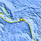
| Location | 10.842°S, 164.172°E |
| Depth | 35 km (21.7 miles) set by location program |
| Region | SANTA CRUZ ISLANDS REGION |
| Distances | 180 km (115 miles) W of Lata, Santa Cruz Islands, Solomon Isl. 250 km (155 miles) E of Kira Kira, San Cristobal, Solomon Isl. 485 km (300 miles) ESE of HONIARA, Guadalcanal, Solomon Islands 2175 km (1350 miles) NE of BRISBANE, Queensland, Australia |
| Location Uncertainty | horizontal +/- 27.5 km (17.1 miles); depth fixed by location program |
| Parameters | NST= 10, Nph= 10, Dmin=488.6 km, Rmss=1.43 sec, Gp=216°, M-type=body wave magnitude (Mb), Version=7 |
| Source |
|
| Event ID | us2009fwad |
- This event has been reviewed by a seismologist.
- Did you feel it? Report shaking and damage at your location. You can also view a map displaying accumulated data from your report and others.
Earthquake Maps


Scientific & Technical Information
 Historic Moment Tensor Solutions
- Preliminary Earthquake Report
- U.S. Geological Survey, National Earthquake Information Center:
World Data Center for Seismology, Denver
