
 Feeds & Data
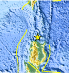
Magnitude 4.7 - LUZON, PHILIPPINES
2009 April 24 10:55:49 UTC
Earthquake Details
| Magnitude | 4.7 |
|---|---|
| Date-Time |
|
| Location | 18.951°N, 121.354°E |
| Depth | 35 km (21.7 miles) set by location program |
| Region | LUZON, PHILIPPINES |
| Distances | 110 km (70 miles) NE of Laoag, Luzon, Philippines 175 km (110 miles) SSW of Basco, Batan Islands, Philippines 480 km (300 miles) N of MANILA, Philippines 680 km (420 miles) S of T'AI-PEI, Taiwan |
| Location Uncertainty | horizontal +/- 13 km (8.1 miles); depth fixed by location program |
| Parameters | NST= 18, Nph= 18, Dmin=487.6 km, Rmss=1.14 sec, Gp=122°, M-type=body wave magnitude (Mb), Version=7 |
| Source |
|
| Event ID | us2009fvaw |
- This event has been reviewed by a seismologist.
- Did you feel it? Report shaking and damage at your location. You can also view a map displaying accumulated data from your report and others.

Earthquake Maps


Scientific & Technical Information
 Historic Moment Tensor Solutions
- Preliminary Earthquake Report
- U.S. Geological Survey, National Earthquake Information Center:
World Data Center for Seismology, Denver
