
 Feeds & Data
Magnitude 4.7 - BANDA SEA
2009 April 24 15:20:41 UTC
Earthquake Details
| Magnitude | 4.7 |
|---|---|
| Date-Time |
|
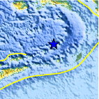
| Location | 6.596°S, 129.357°E |
| Depth | 207.6 km (129.0 miles) |
| Region | BANDA SEA |
| Distances | 270 km (165 miles) NW of Saumlaki, Tanimbar Islands, Indonesia 350 km (215 miles) SSE of Ambon, Moluccas, Indonesia 670 km (415 miles) NNW of DARWIN, Northern Territory, Australia 2505 km (1550 miles) E of JAKARTA, Java, Indonesia |
| Location Uncertainty | horizontal +/- 13 km (8.1 miles); depth +/- 19.5 km (12.1 miles) |
| Parameters | NST= 10, Nph= 10, Dmin=237.1 km, Rmss=0.51 sec, Gp= 86°, M-type=body wave magnitude (Mb), Version=6 |
| Source |
|
| Event ID | us2009fva8 |
- This event has been reviewed by a seismologist.
- Did you feel it? Report shaking and damage at your location. You can also view a map displaying accumulated data from your report and others.

Earthquake Maps


Scientific & Technical Information
 Historic Moment Tensor Solutions
- Preliminary Earthquake Report
- U.S. Geological Survey, National Earthquake Information Center:
World Data Center for Seismology, Denver
