
 Feeds & Data
Magnitude 4.5 - FIJI REGION
2009 April 23 08:59:36 UTC
Earthquake Details
| Magnitude | 4.5 |
|---|---|
| Date-Time |
|
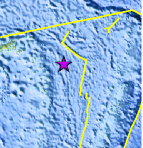
| Location | 17.549°S, 177.407°W |
| Depth | 391.1 km (243.0 miles) |
| Region | FIJI REGION |
| Distances | 365 km (225 miles) ESE of Lambasa, Vanua Levu, Fiji 370 km (230 miles) SSE of Sigave, Ile Futuna, Wallis and Futuna 445 km (280 miles) E of SUVA, Viti Levu, Fiji 2280 km (1410 miles) NNE of Auckland, New Zealand |
| Location Uncertainty | horizontal +/- 17.8 km (11.1 miles); depth +/- 10.5 km (6.5 miles) |
| Parameters | NST= 63, Nph= 63, Dmin=482.6 km, Rmss=0.54 sec, Gp=122°, M-type=body wave magnitude (Mb), Version=Q |
| Source |
|
| Event ID | us2009fuar |
- This event has been reviewed by a seismologist.
- Did you feel it? Report shaking and damage at your location. You can also view a map displaying accumulated data from your report and others.
Earthquake Maps


Scientific & Technical Information
 Historic Moment Tensor Solutions
- Preliminary Earthquake Report
- U.S. Geological Survey, National Earthquake Information Center:
World Data Center for Seismology, Denver
