
 Feeds & Data
Magnitude 4.6 - SOLOMON ISLANDS
2009 April 22 10:38:12 UTC
Earthquake Details
| Magnitude | 4.6 |
|---|---|
| Date-Time |
|
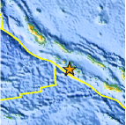
| Location | 8.469°S, 157.410°E |
| Depth | 10 km (6.2 miles) set by location program |
| Region | SOLOMON ISLANDS |
| Distances | 75 km (45 miles) ESE of Gizo, New Georgia Islands, Solomon Isl. 185 km (115 miles) WSW of Dadali, Santa Isabel, Solomon Islands 300 km (185 miles) WNW of HONIARA, Guadalcanal, Solomon Islands 2160 km (1340 miles) NNE of BRISBANE, Queensland, Australia |
| Location Uncertainty | horizontal +/- 13.4 km (8.3 miles); depth fixed by location program |
| Parameters | NST= 16, Nph= 16, Dmin=298.7 km, Rmss=1.13 sec, Gp= 90°, M-type=body wave magnitude (Mb), Version=Q |
| Source |
|
| Event ID | us2009ftay |
- This event has been reviewed by a seismologist.
- Did you feel it? Report shaking and damage at your location. You can also view a map displaying accumulated data from your report and others.
Earthquake Maps


Scientific & Technical Information
 Historic Moment Tensor Solutions
- Preliminary Earthquake Report
- U.S. Geological Survey, National Earthquake Information Center:
World Data Center for Seismology, Denver
