
 Feeds & Data
Magnitude 4.6 - BANDA SEA
2009 April 21 01:41:20 UTC
Earthquake Details
| Magnitude | 4.6 |
|---|---|
| Date-Time |
|
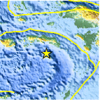
| Location | 4.301°S, 129.729°E |
| Depth | 39.8 km (24.7 miles) (poorly constrained) |
| Region | BANDA SEA |
| Distances | 185 km (115 miles) ESE of Ambon, Moluccas, Indonesia 420 km (260 miles) SSW of Sorong, Papua, Indonesia 915 km (570 miles) N of DARWIN, Northern Territory, Australia 2550 km (1590 miles) E of JAKARTA, Java, Indonesia |
| Location Uncertainty | horizontal +/- 17.4 km (10.8 miles); depth +/- 41.4 km (25.7 miles) |
| Parameters | NST= 17, Nph= 17, Dmin=>999 km, Rmss=0.79 sec, Gp=126°, M-type=body wave magnitude (Mb), Version=Q |
| Source |
|
| Event ID | us2009fsag |
- This event has been reviewed by a seismologist.
- Did you feel it? Report shaking and damage at your location. You can also view a map displaying accumulated data from your report and others.

Earthquake Maps


Scientific & Technical Information
 Historic Moment Tensor Solutions
- Preliminary Earthquake Report
- U.S. Geological Survey, National Earthquake Information Center:
World Data Center for Seismology, Denver
