
 Feeds & Data
Magnitude 5.8 - VANUATU
2009 April 21 00:53:14 UTC
Earthquake Details
| Magnitude | 5.8 |
|---|---|
| Date-Time |
|
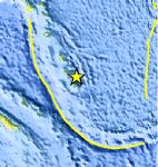
| Location | 19.757°S, 169.870°E |
| Depth | 42.6 km (26.5 miles) |
| Region | VANUATU |
| Distances | 65 km (40 miles) ESE of Isangel, Tanna, Vanuatu 275 km (170 miles) SE of PORT-VILA, Efate, Vanuatu 285 km (175 miles) NE of Tadine, Loyalty Islands, New Caledonia 1920 km (1190 miles) ENE of BRISBANE, Queensland, Australia |
| Location Uncertainty | horizontal +/- 8.1 km (5.0 miles); depth +/- 16 km (9.9 miles) |
| Parameters | NST= 98, Nph= 98, Dmin=891 km, Rmss=1.07 sec, Gp= 54°, M-type=centroid moment magnitude (Mw), Version=7 |
| Source |
|
| Event ID | us2009fsad |
- This event has been reviewed by a seismologist.
- Did you feel it? Report shaking and damage at your location. You can also view a map displaying accumulated data from your report and others.
Earthquake Summary

Felt Reports
WP 6.0 (HDRA).
 Tsunami Information
- NOAA West Coast & Alaska Tsunami Warning Center
- NOAA Pacific Tsunami Warning Center
- Tsunami Information Links
The earthquake locations and magnitudes cited in these NOAA tsunami bulletins are very preliminary and may be superceded by USGS locations and magnitudes computed using more extensive data sets.
Earthquake Maps


Scientific & Technical Information

- Preliminary Earthquake Report
- U.S. Geological Survey, National Earthquake Information Center:
World Data Center for Seismology, Denver
