
 Feeds & Data
Magnitude 4.6 - BABUYAN ISLANDS REGION, PHILIPPINES
2009 April 21 00:37:39 UTC
Earthquake Details
| Magnitude | 4.6 |
|---|---|
| Date-Time |
|
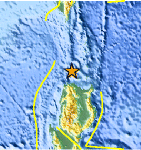
| Location | 19.242°N, 121.053°E |
| Depth | 28.1 km (17.5 miles) (poorly constrained) |
| Region | BABUYAN ISLANDS REGION, PHILIPPINES |
| Distances | 120 km (75 miles) NNE of Laoag, Luzon, Philippines 165 km (100 miles) SW of Basco, Batan Islands, Philippines 510 km (320 miles) N of MANILA, Philippines 650 km (405 miles) S of T'AI-PEI, Taiwan |
| Location Uncertainty | horizontal +/- 33.9 km (21.1 miles); depth +/- 35.1 km (21.8 miles) |
| Parameters | NST= 13, Nph= 15, Dmin=396.3 km, Rmss=0.55 sec, Gp=202°, M-type=body wave magnitude (Mb), Version=6 |
| Source |
|
| Event ID | us2009fsac |
- This event has been reviewed by a seismologist.
- Did you feel it? Report shaking and damage at your location. You can also view a map displaying accumulated data from your report and others.

Earthquake Maps


Scientific & Technical Information
 Historic Moment Tensor Solutions
- Preliminary Earthquake Report
- U.S. Geological Survey, National Earthquake Information Center:
World Data Center for Seismology, Denver
