
 Feeds & Data
Magnitude 4.9 - LUZON, PHILIPPINES
2009 April 20 19:12:42 UTC
Earthquake Details
| Magnitude | 4.9 |
|---|---|
| Date-Time |
|
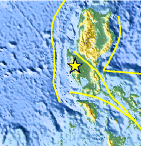
| Location | 15.435°N, 120.241°E |
| Depth | 61.6 km (38.3 miles) |
| Region | LUZON, PHILIPPINES |
| Distances | 45 km (30 miles) NW of Angeles, Luzon, Philippines 70 km (45 miles) N of Olongapo, Luzon, Philippines 70 km (45 miles) S of Dagupan, Luzon, Philippines 120 km (75 miles) NW of MANILA, Philippines |
| Location Uncertainty | horizontal +/- 9.5 km (5.9 miles); depth +/- 7.9 km (4.9 miles) |
| Parameters | NST= 47, Nph= 47, Dmin=822.5 km, Rmss=1.07 sec, Gp=112°, M-type=body wave magnitude (Mb), Version=6 |
| Source |
|
| Event ID | us2009frbp |
- This event has been reviewed by a seismologist.
- Did you feel it? Report shaking and damage at your location. You can also view a map displaying accumulated data from your report and others.

Earthquake Maps


Scientific & Technical Information
 Historic Moment Tensor Solutions
- Preliminary Earthquake Report
- U.S. Geological Survey, National Earthquake Information Center:
World Data Center for Seismology, Denver
