
 Feeds & Data
Magnitude 4.7 - TONGA REGION
2009 April 19 23:15:53 UTC
Earthquake Details
| Magnitude | 4.7 |
|---|---|
| Date-Time |
|
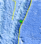
| Location | 22.937°S, 174.936°W |
| Depth | 106.4 km (66.1 miles) |
| Region | TONGA REGION |
| Distances | 200 km (125 miles) S of NUKU'ALOFA, Tonga 465 km (290 miles) ESE of Ndoi Island, Fiji 485 km (300 miles) SSW of Neiafu, Tonga 1830 km (1140 miles) NE of Auckland, New Zealand |
| Location Uncertainty | horizontal +/- 36.3 km (22.6 miles); depth +/- 7.7 km (4.8 miles) |
| Parameters | NST= 27, Nph= 28, Dmin=931.7 km, Rmss=0.68 sec, Gp=191°, M-type=body wave magnitude (Mb), Version=6 |
| Source |
|
| Event ID | us2009fqb6 |
- This event has been reviewed by a seismologist.
- Did you feel it? Report shaking and damage at your location. You can also view a map displaying accumulated data from your report and others.
Earthquake Maps


Scientific & Technical Information
 Historic Moment Tensor Solutions
- Preliminary Earthquake Report
- U.S. Geological Survey, National Earthquake Information Center:
World Data Center for Seismology, Denver
