
 Feeds & Data
Magnitude 5.4 - KEPULAUAN BARAT DAYA, INDONESIA
2009 April 17 04:09:59 UTC
Earthquake Details
| Magnitude | 5.4 |
|---|---|
| Date-Time |
|
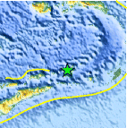
| Location | 7.402°S, 128.263°E |
| Depth | 136.9 km (85.1 miles) |
| Region | KEPULAUAN BARAT DAYA, INDONESIA |
| Distances | 325 km (200 miles) ENE of DILI, East Timor 350 km (215 miles) W of Saumlaki, Tanimbar Islands, Indonesia 410 km (255 miles) S of Ambon, Moluccas, Indonesia 625 km (390 miles) NNW of DARWIN, Northern Territory, Australia |
| Location Uncertainty | horizontal +/- 5.3 km (3.3 miles); depth +/- 9.9 km (6.2 miles) |
| Parameters | NST=205, Nph=205, Dmin=978.2 km, Rmss=0.78 sec, Gp= 22°, M-type=centroid moment magnitude (Mw), Version=Q |
| Source |
|
| Event ID | us2009fnaj |
- This event has been reviewed by a seismologist.
- Did you feel it? Report shaking and damage at your location. You can also view a map displaying accumulated data from your report and others.

Earthquake Maps


Scientific & Technical Information

- Preliminary Earthquake Report
- U.S. Geological Survey, National Earthquake Information Center:
World Data Center for Seismology, Denver
