
 Feeds & Data
Magnitude 4.9 - KEPULAUAN MENTAWAI REGION, INDONESIA
2009 April 16 20:42:31 UTC
Earthquake Details
| Magnitude | 4.9 |
|---|---|
| Date-Time |
|
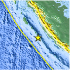
| Location | 3.338°S, 100.357°E |
| Depth | 35 km (21.7 miles) set by location program |
| Region | KEPULAUAN MENTAWAI REGION, INDONESIA |
| Distances | 215 km (135 miles) WNW of Bengkulu, Sumatra, Indonesia 265 km (165 miles) S of Padang, Sumatra, Indonesia 410 km (255 miles) WSW of Jambi, Sumatra, Indonesia 775 km (480 miles) WNW of JAKARTA, Java, Indonesia |
| Location Uncertainty | horizontal +/- 12.2 km (7.6 miles); depth fixed by location program |
| Parameters | NST= 33, Nph= 33, Dmin=878.7 km, Rmss=1.18 sec, Gp=112°, M-type=body wave magnitude (Mb), Version=6 |
| Source |
|
| Event ID | us2009fmbq |
- This event has been reviewed by a seismologist.
- Did you feel it? Report shaking and damage at your location. You can also view a map displaying accumulated data from your report and others.

Earthquake Maps


Scientific & Technical Information
 Historic Moment Tensor Solutions
- Preliminary Earthquake Report
- U.S. Geological Survey, National Earthquake Information Center:
World Data Center for Seismology, Denver
