
 Feeds & Data
Magnitude 5.8 - KEPULAUAN MENTAWAI REGION, INDONESIA
2009 April 15 17:47:27 UTC
Earthquake Details
| Magnitude | 5.8 |
|---|---|
| Date-Time |
|
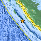
| Location | 3.088°S, 100.430°E |
| Depth | 14.6 km (9.1 miles) (poorly constrained) |
| Region | KEPULAUAN MENTAWAI REGION, INDONESIA |
| Distances | 215 km (135 miles) WNW of Bengkulu, Sumatra, Indonesia 235 km (145 miles) S of Padang, Sumatra, Indonesia 390 km (245 miles) WSW of Jambi, Sumatra, Indonesia 775 km (480 miles) WNW of JAKARTA, Java, Indonesia |
| Location Uncertainty | horizontal +/- 8.4 km (5.2 miles); depth +/- 29.4 km (18.3 miles) |
| Parameters | NST=138, Nph=138, Dmin=850.9 km, Rmss=1.1 sec, Gp= 36°, M-type=centroid moment magnitude (Mw), Version=8 |
| Source |
|
| Event ID | us2009fla8 |
- This event has been reviewed by a seismologist.
- Did you feel it? Report shaking and damage at your location. You can also view a map displaying accumulated data from your report and others.
Earthquake Summary

Earthquake Information for Asia
Earthquake Information for Indonesia
 Tsunami Information
- NOAA West Coast & Alaska Tsunami Warning Center
- NOAA Pacific Tsunami Warning Center
- Tsunami Information Links
The earthquake locations and magnitudes cited in these NOAA tsunami bulletins are very preliminary and may be superceded by USGS locations and magnitudes computed using more extensive data sets.
Earthquake Maps


Scientific & Technical Information

- Preliminary Earthquake Report
- U.S. Geological Survey, National Earthquake Information Center:
World Data Center for Seismology, Denver
