
 Feeds & Data
Magnitude 4.4 - MINDANAO, PHILIPPINES
2009 April 14 18:02:48 UTC
Earthquake Details
| Magnitude | 4.4 |
|---|---|
| Date-Time |
|
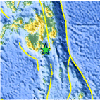
| Location | 6.063°N, 125.603°E |
| Depth | 79.6 km (49.5 miles) |
| Region | MINDANAO, PHILIPPINES |
| Distances | 45 km (30 miles) E of General Santos, Mindanao, Philippines 115 km (70 miles) S of Davao, Mindanao, Philippines 200 km (125 miles) SE of Cotabato, Mindanao, Philippines 1065 km (670 miles) SSE of MANILA, Philippines |
| Location Uncertainty | horizontal +/- 9.1 km (5.7 miles); depth +/- 9.3 km (5.8 miles) |
| Parameters | NST= 36, Nph= 36, Dmin=111.4 km, Rmss=0.93 sec, Gp= 94°, M-type=body wave magnitude (Mb), Version=Q |
| Source |
|
| Event ID | us2009fkbe |
- This event has been reviewed by a seismologist.
- Did you feel it? Report shaking and damage at your location. You can also view a map displaying accumulated data from your report and others.

Earthquake Maps


Scientific & Technical Information
 Historic Moment Tensor Solutions
- Preliminary Earthquake Report
- U.S. Geological Survey, National Earthquake Information Center:
World Data Center for Seismology, Denver
