
 Feeds & Data
Magnitude 4.7 - PAPUA, INDONESIA
2009 April 13 06:46:04 UTC
Earthquake Details
| Magnitude | 4.7 |
|---|---|
| Date-Time |
|
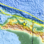
| Location | 3.419°S, 139.440°E |
| Depth | 62.1 km (38.6 miles) |
| Region | PAPUA, INDONESIA |
| Distances | 170 km (105 miles) SW of Jayapura, Papua, Indonesia 220 km (135 miles) WSW of Vanimo, New Guinea, PNG 1380 km (860 miles) NE of DARWIN, Northern Territory, Australia 3630 km (2260 miles) E of JAKARTA, Java, Indonesia |
| Location Uncertainty | horizontal +/- 24.5 km (15.2 miles); depth +/- 28.8 km (17.9 miles) |
| Parameters | NST= 12, Nph= 12, Dmin=>999 km, Rmss=0.84 sec, Gp=194°, M-type=body wave magnitude (Mb), Version=7 |
| Source |
|
| Event ID | us2009fjap |
- This event has been reviewed by a seismologist.
- Did you feel it? Report shaking and damage at your location. You can also view a map displaying accumulated data from your report and others.

Earthquake Maps


Scientific & Technical Information
 Historic Moment Tensor Solutions
- Preliminary Earthquake Report
- U.S. Geological Survey, National Earthquake Information Center:
World Data Center for Seismology, Denver
