
 Feeds & Data
Magnitude 4.9 - FIJI REGION
2009 April 13 05:30:41 UTC
Earthquake Details
| Magnitude | 4.9 |
|---|---|
| Date-Time |
|
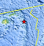
| Location | 17.839°S, 178.641°W |
| Depth | 546.4 km (339.5 miles) |
| Region | FIJI REGION |
| Distances | 260 km (165 miles) SE of Lambasa, Vanua Levu, Fiji 310 km (195 miles) N of Ndoi Island, Fiji 315 km (195 miles) E of SUVA, Viti Levu, Fiji 2205 km (1370 miles) NNE of Auckland, New Zealand |
| Location Uncertainty | horizontal +/- 10.8 km (6.7 miles); depth +/- 8.7 km (5.4 miles) |
| Parameters | NST= 77, Nph= 77, Dmin=351.1 km, Rmss=0.87 sec, Gp= 76°, M-type=body wave magnitude (Mb), Version=7 |
| Source |
|
| Event ID | us2009fjal |
- This event has been reviewed by a seismologist.
- Did you feel it? Report shaking and damage at your location. You can also view a map displaying accumulated data from your report and others.
Earthquake Maps


Scientific & Technical Information
 Historic Moment Tensor Solutions
- Preliminary Earthquake Report
- U.S. Geological Survey, National Earthquake Information Center:
World Data Center for Seismology, Denver
