
 Feeds & Data
Magnitude 5.1 - KEPULAUAN SANGIHE, INDONESIA
2009 April 11 21:45:22 UTC
Earthquake Details
| Magnitude | 5.1 |
|---|---|
| Date-Time |
|
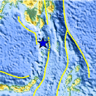
| Location | 4.406°N, 125.557°E |
| Depth | 159.2 km (98.9 miles) |
| Region | KEPULAUAN SANGIHE, INDONESIA |
| Distances | 195 km (120 miles) S of General Santos, Mindanao, Philippines 300 km (185 miles) S of Davao, Mindanao, Philippines 1230 km (770 miles) SSE of MANILA, Philippines 2385 km (1480 miles) ENE of JAKARTA, Java, Indonesia |
| Location Uncertainty | horizontal +/- 8 km (5.0 miles); depth +/- 12.8 km (8.0 miles) |
| Parameters | NST= 33, Nph= 33, Dmin=295 km, Rmss=0.86 sec, Gp= 58°, M-type=body wave magnitude (Mb), Version=6 |
| Source |
|
| Event ID | us2009fhbj |
- This event has been reviewed by a seismologist.
- Did you feel it? Report shaking and damage at your location. You can also view a map displaying accumulated data from your report and others.
Earthquake Summary

Earthquake Information for Asia
Earthquake Information for Indonesia
 Tsunami Information
- NOAA West Coast & Alaska Tsunami Warning Center
- NOAA Pacific Tsunami Warning Center
- Tsunami Information Links
The earthquake locations and magnitudes cited in these NOAA tsunami bulletins are very preliminary and may be superceded by USGS locations and magnitudes computed using more extensive data sets.
Earthquake Maps


Scientific & Technical Information
 Historic Moment Tensor Solutions
- Preliminary Earthquake Report
- U.S. Geological Survey, National Earthquake Information Center:
World Data Center for Seismology, Denver
