
 Feeds & Data
Magnitude 4.6 - SAMOA ISLANDS REGION
2009 April 09 18:49:08 UTC
Earthquake Details
| Magnitude | 4.6 |
|---|---|
| Date-Time |
|
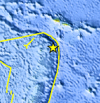
| Location | 15.765°S, 172.772°W |
| Depth | 35 km (21.7 miles) set by location program |
| Region | SAMOA ISLANDS REGION |
| Distances | 105 km (65 miles) E of Hihifo, Tonga 245 km (150 miles) SSW of APIA, Samoa 650 km (405 miles) NNE of NUKU'ALOFA, Tonga 2640 km (1640 miles) NNE of Auckland, New Zealand |
| Location Uncertainty | horizontal +/- 23 km (14.3 miles); depth fixed by location program |
| Parameters | NST= 28, Nph= 28, Dmin=>999 km, Rmss=1.12 sec, Gp=140°, M-type=body wave magnitude (Mb), Version=6 |
| Source |
|
| Event ID | us2009ffb2 |
- This event has been reviewed by a seismologist.
- Did you feel it? Report shaking and damage at your location. You can also view a map displaying accumulated data from your report and others.
Earthquake Maps


Scientific & Technical Information
 Historic Moment Tensor Solutions
- Preliminary Earthquake Report
- U.S. Geological Survey, National Earthquake Information Center:
World Data Center for Seismology, Denver
