
 Feeds & Data
Magnitude 4.8 - SUMBA REGION, INDONESIA
2009 April 09 08:18:37 UTC
Earthquake Details
| Magnitude | 4.8 |
|---|---|
| Date-Time |
|
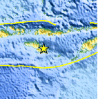
| Location | 9.968°S, 120.567°E |
| Depth | 35 km (21.7 miles) set by location program |
| Region | SUMBA REGION, INDONESIA |
| Distances | 175 km (105 miles) SW of Ende, Flores, Indonesia 260 km (160 miles) SE of Raba, Sumbawa, Indonesia 1155 km (720 miles) WNW of DARWIN, Northern Territory, Australia 1575 km (980 miles) ESE of JAKARTA, Java, Indonesia |
| Location Uncertainty | horizontal +/- 13.3 km (8.3 miles); depth fixed by location program |
| Parameters | NST= 22, Nph= 22, Dmin=555.2 km, Rmss=1.05 sec, Gp= 94°, M-type=body wave magnitude (Mb), Version=Q |
| Source |
|
| Event ID | us2009ffa1 |
- This event has been reviewed by a seismologist.
- Did you feel it? Report shaking and damage at your location. You can also view a map displaying accumulated data from your report and others.

Earthquake Maps


Scientific & Technical Information
 Historic Moment Tensor Solutions
- Preliminary Earthquake Report
- U.S. Geological Survey, National Earthquake Information Center:
World Data Center for Seismology, Denver
