
 Feeds & Data
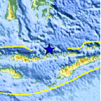
Magnitude 4.5 - FLORES SEA
2009 April 07 14:20:10 UTC
Earthquake Details
| Magnitude | 4.5 |
|---|---|
| Date-Time |
|
| Location | 7.970°S, 122.916°E |
| Depth | 236.7 km (147.1 miles) |
| Region | FLORES SEA |
| Distances | 170 km (105 miles) NE of Ende, Flores, Indonesia 255 km (155 miles) NNW of Kupang, Timor, Indonesia 1005 km (620 miles) WNW of DARWIN, Northern Territory, Australia 1800 km (1120 miles) E of JAKARTA, Java, Indonesia |
| Location Uncertainty | horizontal +/- 15.3 km (9.5 miles); depth +/- 11 km (6.8 miles) |
| Parameters | NST= 21, Nph= 21, Dmin=478.9 km, Rmss=0.66 sec, Gp=115°, M-type=body wave magnitude (Mb), Version=Q |
| Source |
|
| Event ID | us2009fda8 |
- This event has been reviewed by a seismologist.
- Did you feel it? Report shaking and damage at your location. You can also view a map displaying accumulated data from your report and others.

Earthquake Maps


Scientific & Technical Information
 Historic Moment Tensor Solutions
- Preliminary Earthquake Report
- U.S. Geological Survey, National Earthquake Information Center:
World Data Center for Seismology, Denver
