
 Feeds & Data
Magnitude 4.7 - TIMOR REGION
2009 April 05 22:11:17 UTC
Earthquake Details
| Magnitude | 4.7 |
|---|---|
| Date-Time |
|
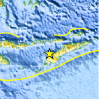
| Location | 9.397°S, 124.003°E |
| Depth | 35 km (21.7 miles) set by location program |
| Region | TIMOR REGION |
| Distances | 95 km (60 miles) NNE of Kupang, Timor, Indonesia 195 km (120 miles) WSW of DILI, East Timor 825 km (510 miles) WNW of DARWIN, Northern Territory, Australia 1935 km (1200 miles) ESE of JAKARTA, Java, Indonesia |
| Location Uncertainty | horizontal +/- 12.9 km (8.0 miles); depth fixed by location program |
| Parameters | NST= 27, Nph= 27, Dmin=211.5 km, Rmss=0.97 sec, Gp= 72°, M-type=body wave magnitude (Mb), Version=6 |
| Source |
|
| Event ID | us2009fbbs |
- This event has been reviewed by a seismologist.
- Did you feel it? Report shaking and damage at your location. You can also view a map displaying accumulated data from your report and others.

Earthquake Maps


Scientific & Technical Information
 Historic Moment Tensor Solutions
- Preliminary Earthquake Report
- U.S. Geological Survey, National Earthquake Information Center:
World Data Center for Seismology, Denver
