
 Feeds & Data
Magnitude 4.5 - NEGROS, PHILIPPINES
2009 April 04 19:11:02 UTC
Earthquake Details
| Magnitude | 4.5 |
|---|---|
| Date-Time |
|
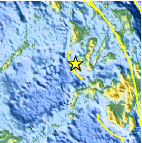
| Location | 9.459°N, 122.261°E |
| Depth | 35 km (21.7 miles) set by location program |
| Region | NEGROS, PHILIPPINES |
| Distances | 115 km (70 miles) W of Dumaguete, Negros, Philippines 140 km (85 miles) SSW of Iloilo, Panay, Philippines 150 km (95 miles) SSW of Bacolod, Negros, Philippines 585 km (365 miles) SSE of MANILA, Philippines |
| Location Uncertainty | horizontal +/- 12.5 km (7.8 miles); depth fixed by location program |
| Parameters | NST= 22, Nph= 22, Dmin=766.4 km, Rmss=0.98 sec, Gp=173°, M-type=body wave magnitude (Mb), Version=S |
| Source |
|
| Event ID | us2009fabn |
- This event has been reviewed by a seismologist.
- Did you feel it? Report shaking and damage at your location. You can also view a map displaying accumulated data from your report and others.

Earthquake Maps


Scientific & Technical Information
 Historic Moment Tensor Solutions
- Preliminary Earthquake Report
- U.S. Geological Survey, National Earthquake Information Center:
World Data Center for Seismology, Denver
