
 Feeds & Data
Magnitude 6.3 - PHILIPPINE ISLANDS REGION
2009 April 04 05:31:55 UTC
Earthquake Details
| Magnitude | 6.3 |
|---|---|
| Date-Time |
|
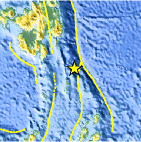
| Location | 5.141°N, 127.198°E |
| Depth | 48 km (29.8 miles) set by location program |
| Region | PHILIPPINE ISLANDS REGION |
| Distances | 250 km (155 miles) ESE of General Santos, Mindanao, Philippines 275 km (170 miles) SE of Davao, Mindanao, Philippines 1245 km (780 miles) SSE of MANILA, Philippines 2595 km (1610 miles) ENE of JAKARTA, Java, Indonesia |
| Location Uncertainty | horizontal +/- 5 km (3.1 miles); depth fixed by location program |
| Parameters | NST=234, Nph=234, Dmin=>999 km, Rmss=0.95 sec, Gp= 18°, M-type=teleseismic moment magnitude (Mw), Version=T |
| Source |
|
| Event ID | us2009faag |
- This event has been reviewed by a seismologist.
- Did you feel it? Report shaking and damage at your location. You can also view a map displaying accumulated data from your report and others.
Earthquake Summary

Felt Reports
Felt (III) at Davao. Also felt at Tagum. Felt (III PIVS) at General Santos, Kidapawan and Mati; (II PIVS) at Malita; (I PIVS) at Makilala.
 Tsunami Information
- NOAA West Coast & Alaska Tsunami Warning Center
- NOAA Pacific Tsunami Warning Center
- Tsunami Information Links
The earthquake locations and magnitudes cited in these NOAA tsunami bulletins are very preliminary and may be superceded by USGS locations and magnitudes computed using more extensive data sets.
Earthquake Maps


Scientific & Technical Information

- Preliminary Earthquake Report
- U.S. Geological Survey, National Earthquake Information Center:
World Data Center for Seismology, Denver
