
 Feeds & Data
Magnitude 4.2 - SOUTH OF THE FIJI ISLANDS
2009 April 04 17:01:27 UTC
Earthquake Details
| Magnitude | 4.2 |
|---|---|
| Date-Time |
|
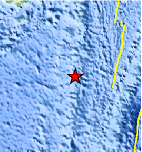
| Location | 22.091°S, 178.758°W |
| Depth | 525.4 km (326.5 miles) |
| Region | SOUTH OF THE FIJI ISLANDS |
| Distances | 160 km (100 miles) S of Ndoi Island, Fiji 380 km (235 miles) WSW of NUKU'ALOFA, Tonga 530 km (330 miles) SSE of SUVA, Viti Levu, Fiji 1755 km (1090 miles) NNE of Auckland, New Zealand |
| Location Uncertainty | horizontal +/- 17.9 km (11.1 miles); depth +/- 16.1 km (10.0 miles) |
| Parameters | NST= 30, Nph= 30, Dmin=587 km, Rmss=1.31 sec, Gp= 65°, M-type=body wave magnitude (Mb), Version=Q |
| Source |
|
| Event ID | us2009faa9 |
- This event has been reviewed by a seismologist.
- Did you feel it? Report shaking and damage at your location. You can also view a map displaying accumulated data from your report and others.
Earthquake Maps


Scientific & Technical Information
 Historic Moment Tensor Solutions
- Preliminary Earthquake Report
- U.S. Geological Survey, National Earthquake Information Center:
World Data Center for Seismology, Denver
