
 Feeds & Data
Magnitude 5.6 - KEPULAUAN TANIMBAR REGION, INDONESIA
2009 April 03 13:37:57 UTC
Earthquake Details
| Magnitude | 5.6 |
|---|---|
| Date-Time |
|
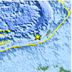
| Location | 8.089°S, 130.212°E |
| Depth | 35 km (21.7 miles) set by location program |
| Region | KEPULAUAN TANIMBAR REGION, INDONESIA |
| Distances | 130 km (80 miles) W of Saumlaki, Tanimbar Islands, Indonesia 490 km (305 miles) N of DARWIN, Northern Territory, Australia 510 km (315 miles) WSW of Dobo, Aru Islands, Indonesia 2595 km (1610 miles) E of JAKARTA, Java, Indonesia |
| Location Uncertainty | horizontal +/- 7.8 km (4.8 miles); depth fixed by location program |
| Parameters | NST= 67, Nph= 67, Dmin=>999 km, Rmss=1 sec, Gp= 50°, M-type=centroid moment magnitude (Mw), Version=7 |
| Source |
|
| Event ID | us2009ezax |
- This event has been reviewed by a seismologist.
- Did you feel it? Report shaking and damage at your location. You can also view a map displaying accumulated data from your report and others.
Earthquake Summary

Felt Reports
WP 5.9 (HDRA).
Earthquake Information for Asia
Earthquake Information for Indonesia
 Tsunami Information
- NOAA West Coast & Alaska Tsunami Warning Center
- NOAA Pacific Tsunami Warning Center
- Tsunami Information Links
The earthquake locations and magnitudes cited in these NOAA tsunami bulletins are very preliminary and may be superceded by USGS locations and magnitudes computed using more extensive data sets.
Earthquake Maps


Scientific & Technical Information

- Preliminary Earthquake Report
- U.S. Geological Survey, National Earthquake Information Center:
World Data Center for Seismology, Denver
