
Seismic Hazard of Western Indonesia
Tectonic Summary
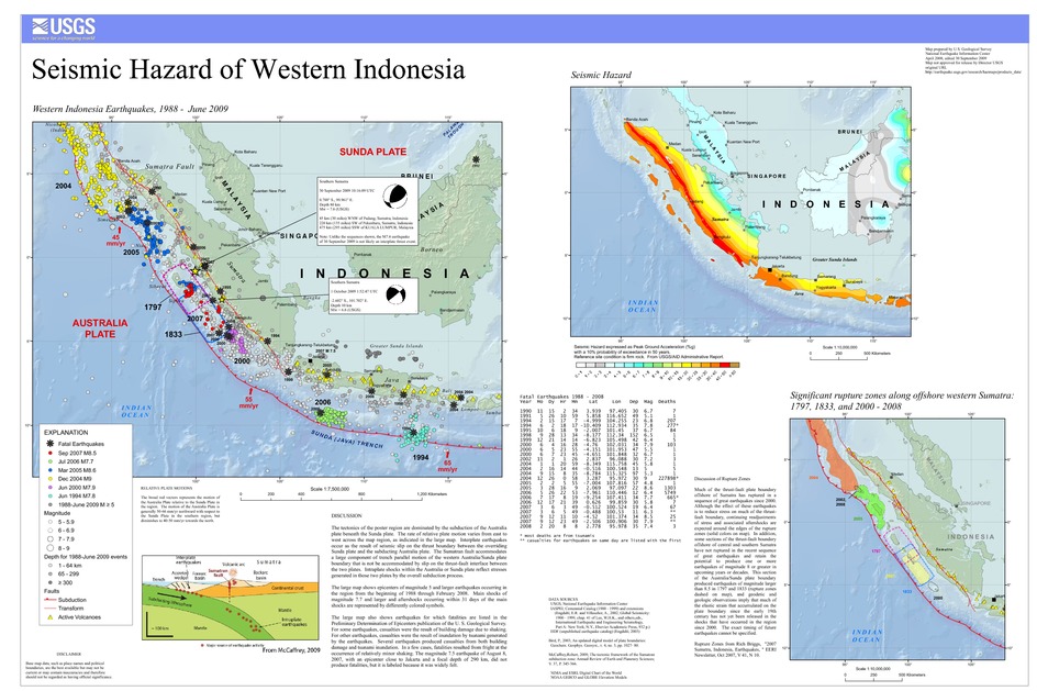
The tectonics of the poster region are dominated by the subduction of the Australia plate beneath the Sunda plate. The rate of relative plate motion varies from east to west across the map region, as indicated in the large map. Interplate earthquakes occur as the result of seismic slip on the thrust boundary between the overriding Sunda plate and the subducting Australia plate. The Sumatran fault accommodates a large component of trench parallel motion of the western Australia/Sunda plate boundary that is not be accommodated by slip on the thrust-fault interface between the two plates. Intraplate shocks within the Australia or Sunda plate reflect stresses generated in those two plates by the overall subduction process.
The large map shows epicenters of magnitude 5 and larger earthquakes occurring in the region from the beginning of 1988 through February 2008. Main shocks of magnitude 7.7 and larger and aftershocks occurring within 31 days of the main shocks are represented by differently colored symbols.
The large map also shows earthquakes for which fatalities are listed in the Preliminary Determination of Epicenters publication of the U. S. Geological Survey. For some earthquakes, casualties were the result of building damage due to shaking. For other earthquakes, casualties were the result of inundation by tsunami generated by the earthquakes. Several earthquakes produced casualties from both building damage and tsunami inundation. In a few cases, fatalities resulted from fright at the occurrence of relatively minor shaking. The magnitude 7.5 earthquake of August 8, 2007, with an epicenter close to Jakarta and a focal depth of 290 km, did not produce fatalities, but it is labeled because it was widely felt.
Downloads
Settings
The posters may be downloaded for viewing or for printing on a color
plotter. Adobe PDF (.pdf) format files are provided. Adobe Acrobat 6.0 or
higher is required for viewing the PDF file on a computer monitor and for
printing the PDF map graphic. IMPORTANT: The PDF map graphic was produced
using TrueType fonts; change the following setting to:
Page(Print)Setup<Properties<Layout<Advanced<Graphic<TrueTypeFont<DownloadAsSoftFont
Attention MAC users: If you have problems viewing the pdf files, please download the pdf file and view it in the lastest verion of Adobe Acrobat.
