
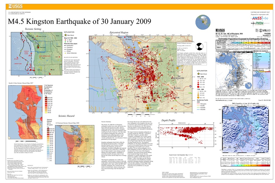
Poster of the Kingston, Washington Earthquake of 30 January 2009 - Magnitude 4.5
Tectonic Summary
The January 30, 2009 Mw=4.5 Kingston earthquake resulted from strike slip motion on a fault within the Juan de Fuca plate, which is subducting beneath North America. Intraplate earthquakes are one of the four earthquake types rumbling the Pacific Northwest. The other types are megathrust earthquakes that rupture the interface between subducting plates, crustal earthquakes that break shallow faults, and volcanic earthquakes that occur because of forces generated by moving magma.
Intraplate earthquakes break faults within the downgoing Juan de Fuca plate. As the plate descends beneath North America, it bends, stretches and compresses, giving rise to earthquakes. Intraplate earthquakes are expected to be limited in size to about M7.2. While they may be large enough to cause damage, ground shaking from deep intraplate earthquakes is somewhat muted by the many miles of rock between the surface and the deep focus of energy release.
The Kingston earthquake was a strike-slip earthquake, with the relative motion of each side of the nearly vertical fault being horizontal. Other earthquakes in this class, such as the 2001 M6.5 Nisqually earthquake, have resulted from the failure of normal faults, where overlying rocks move downward along a fault that dips more gently.
For reasons that are not well understood at this time, earthquakes in the intraplate class give rise to extremely sparse aftershock sequences. Often they have no aftershocks at all. This contrasts with large shallow crustal earthquake that can have hundreds or even thousands of aftershocks.
The largest historical intraplate earthquakes in Cascadia include the 1949 (M7.1 "Olympia"), 1965 (M6.5 "Seattle"), and 2001 (M6.8 "Nisqually") earthquakes, all of which caused extensive damage in the region. The 1949 and 2001 earthquakes were located at the southern end of Puget Sound while the 1965 earthquake was deep beneath Sea-Tac. The Kingston earthquake was the largest earthquake of its class to occur in the northern Kitsap county area since the beginning of the modern era of seismic recording. The last similar earthquake was an M4.8 earthquake on April 25, 2003 that was 50 km deep about 50 km west of the Kingston earthquake, and caused similar ground shaking levels around the Puget Sound. The last earthquake of a similar magnitude in the Seattle region was a shallow, crustal, M4.5 event on October 7, 2006, 4 km deep, near Mt. Rainier. Current estimates of the likelihood of another potentially damaging intraplate earthquake during a 50-year time window with the Puget Sound region put the probability at about 84%, with somewhat lower probabilities as one goes southward.
Downloads
Settings
The posters may be downloaded for viewing or for printing on a color
plotter. Adobe PDF (.pdf) format files are provided. Adobe Acrobat 6.0 or
higher is required for viewing the PDF file on a computer monitor and for
printing the PDF map graphic. IMPORTANT: The PDF map graphic was produced
using TrueType fonts; change the following setting to:
Page(Print)Setup<Properties<Layout<Advanced<Graphic<TrueTypeFont<DownloadAsSoftFont
Attention MAC users: If you have problems viewing the pdf files, please download the pdf file and view it in the lastest verion of Adobe Acrobat.
