
Poster of the East of the Kuril Islands Earthquake of 15 January 2009 - Magnitude 7.4
Tectonic Summary
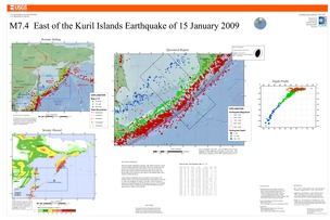
The Kuril Islands earthquake of January 15th, 2009 occurred as a result of thrust faulting within the Pacific plate. The event occurred near the outer-rise of the Pacific plate about 30 km to the east of where the Pacific plate subducts beneath the Okhotsk plate. In this region, the Pacific plate moves northwest with respect to the Okhotsk plate with a velocity of about 90 mm/yr.
Large and great earthquakes are not uncommon in this region. The location of this event is approximately 90 km to the northeast of the Mw 8.1 outer rise earthquake of January 13th 2007, which occurred as a result of normal faulting near the Pacific plate outer-rise. On November 15th 2006, an Mw 8.3 subduction-related thrust earthquake occurred approximately 160km to the southwest.
Downloads
Settings
The posters may be downloaded for viewing or for printing on a color
plotter. Adobe PDF (.pdf) format files are provided. Adobe Acrobat 6.0 or
higher is required for viewing the PDF file on a computer monitor and for
printing the PDF map graphic. IMPORTANT: The PDF map graphic was produced
using TrueType fonts; change the following setting to:
Page(Print)Setup<Properties<Layout<Advanced<Graphic<TrueTypeFont<DownloadAsSoftFont
Attention MAC users: If you have problems viewing the pdf files, please download the pdf file and view it in the lastest verion of Adobe Acrobat.
