
Poster of the Papua, Indonesia Earthquakes of 03 January 2009 - Magnitude 7.6 and 7.4
Tectonic Summary
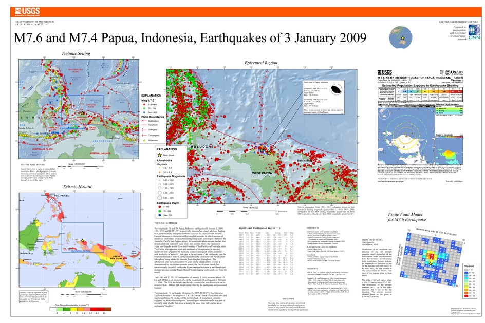
The magnitude 7.6 and 7.4 Papua, Indonesia earthquakes of January 3, 2009, 19:43 UTC and 22:33 UTC, respectively, occurred as a result of thrust faulting on a plate-boundary along the northwest coast of the island of New Guinea. Eastern Indonesia is characterized by complex tectonics in which motions of numerous small plates are accommodating large-scale convergence between the Australia, Pacific, and Eurasia plates. In broad-scale plate-tectonic models that do not subdivide continent sized plates into smaller plates, the location of today's earthquake would be on the boundary of the Pacific and Australia plates. The Pacific plate (located north and northeast of the epicenter) is moving southwest with respect to the Australia plate (located south of the epicenter) with a velocity of about 112 mm/year at the epicenter of the earthquake, and the focal-mechanism of today's earthquake is broadly consistent with Pacific plate lithosphere being subducted beneath Australia plate lithosphere. The subduction zone along the northwest coast of New Guinea is characterized by an offshore oceanic trench, the New Guinea trench, but teleseismically recorded earthquake hypocenters do not show a well-developed inclined seismic zone (a Wadati-Benioff zone) dipping south-southwest from the trench.
The earthquake of January 3, 2008, 19:43 UTC, occurred about 470 km west of the magnitude 8.2 earthquake of February 17, 1996. The 1996 earthquake produced a tsunami that was destructive on the island of Biak. At least 108 people were killed by the earthquake and associated tsunami.
The earthquake of January 3, 2009, 22:33 UTC, occurred about 400 km west of the magnitude 8.2 earthquake of February 17, 1996. The 1996 earthquake produced a tsunami that was destructive on the island of Biak. At least 108 people were killed by the earthquake and associated tsunami.
The magnitude 7.4 earthquake of January 3, 2009, 22:33 UTC, had the same focal-mechanism as the magnitude 7.6 shock of the same date, 19:43 UTC, and was located about 70 km east of the earlier shock. It was almost certainly triggered by the earlier earthquake. Seismologists sometimes refer to a pair of similarly sized shocks that occur at nearly the same time and location as an earthquake "doublet."
Downloads

Settings
The posters may be downloaded for viewing or for printing on a color
plotter. Adobe PDF (.pdf) format files are provided. Adobe Acrobat 6.0 or
higher is required for viewing the PDF file on a computer monitor and for
printing the PDF map graphic. IMPORTANT: The PDF map graphic was produced
using TrueType fonts; change the following setting to:
Page(Print)Setup<Properties<Layout<Advanced<Graphic<TrueTypeFont<DownloadAsSoftFont
Attention MAC users: If you have problems viewing the pdf files, please download the pdf file and view it in the lastest verion of Adobe Acrobat.
Tectonic Summary
The magnitude 7.6 and 7.4 Papua, Indonesia earthquakes of January 3, 2009, 19:43 UTC and 22:33 UTC, respectively, occurred as a result of thrust faulting on a plate-boundary along the northwest coast of the island of New Guinea. Eastern Indonesia is characterized by complex tectonics in which motions of numerous small plates are accommodating large-scale convergence between the Australia, Pacific, and Eurasia plates. In broad-scale plate-tectonic models that do not subdivide continent sized plates into smaller plates, the location of today's earthquake would be on the boundary of the Pacific and Australia plates. The Pacific plate (located north and northeast of the epicenter) is moving southwest with respect to the Australia plate (located south of the epicenter) with a velocity of about 112 mm/year at the epicenter of the earthquake, and the focal-mechanism of today's earthquake is broadly consistent with Pacific plate lithosphere being subducted beneath Australia plate lithosphere. The subduction zone along the northwest coast of New Guinea is characterized by an offshore oceanic trench, the New Guinea trench, but teleseismically recorded earthquake hypocenters do not show a well-developed inclined seismic zone (a Wadati-Benioff zone) dipping south-southwest from the trench.
The earthquake of January 3, 2008, 19:43 UTC, occurred about 470 km west of the magnitude 8.2 earthquake of February 17, 1996. The 1996 earthquake produced a tsunami that was destructive on the island of Biak. At least 108 people were killed by the earthquake and associated tsunami.
The earthquake of January 3, 2009, 22:33 UTC, occurred about 400 km west of the magnitude 8.2 earthquake of February 17, 1996. The 1996 earthquake produced a tsunami that was destructive on the island of Biak. At least 108 people were killed by the earthquake and associated tsunami.
The magnitude 7.4 earthquake of January 3, 2009, 22:33 UTC, had the same focal-mechanism as the magnitude 7.6 shock of the same date, 19:43 UTC, and was located about 70 km east of the earlier shock. It was almost certainly triggered by the earlier earthquake. Seismologists sometimes refer to a pair of similarly sized shocks that occur at nearly the same time and location as an earthquake "doublet."
