
Poster of the Yellowstone Lake Earthquake Swarm of December 2008 - January 2009
Tectonic Summary
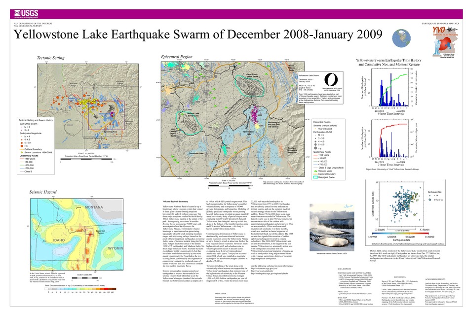
Yellowstone National Park is located a top a Quaternary silicic volcanic system that vented in three giant caldera-forming eruptions between 0.64 and 2.1 million years ago. The three major eruptions resulted in the 60 km by 40 km Yellowstone caldera at the center of the park. Subsequently, more than 30 smaller rhyolite flows, as young as 70,000 years old, were deposited and locally cover the Yellowstone Plateau. The modern volcanic landscape is superimposed on pre-existing topography of north-south trending mountain ranges and intervening valleys formed as the result of large magnitude earthquakes on normal faults; some of the most notable being the Teton fault, Hebgen fault (the source of the deadly 1959 M7.5 earthquake), and Madison faults. No doubt large mountain blocks bounded by faults existed prior to the volcanic activity but they have been modified extensively by the more recent volcanic activity. Nonetheless the pre-existing faults, confirmed by the alignment of contemporary seismicity, produced zones of crustal weakness that also function as conduits for post-caldera magmatic flows.
Seismic tomographic imaging using local earthquakes as sources has revealed a low seismic velocity body identified as an the Yellowstone's "magma chamber" that extends beneath the Yellowstone caldera at depths of 8 to 16 km with 8-15% partial magma melt. This body is responsible for Yellowstone's youthful volcanic history and its expanse of 10,000 geysers, hot springs, and fumaroles. Modeling of globally produced earthquake waves passing beneath Yellowstone revealed an upper-mantle P-wave low-velocity body of partial magma melt extending from 80 to 250 km directly beneath Yellowstone, but tilting 60° west up to 660 km deep, at the bottom of the mantle transition zone and 150 west of Yellowstone - this body is known as the Yellowstone plume.
Contemporary deformation of Yellowstone is dominated by southwest-directed horizontal crustal extension across the Yellowstone Plateau of up to 3 mm/yr, which is about one third of the total regional rate of extension. However, much higher rates of uplift and subsidence due to volcanic processes occur at decadal scales averaging about 2 cm/yr. Unprecedented accelerated uplift (up to 7 cm/yr) has occurred since 2004, which was modeled as magmatic recharge of the Yellowstone magma chamber at depths of 7-10 km.
Tectonic stretching of the crust along with volcanically related stresses are responsible for Yellowstone's earthquakes that represent one of the highest rates of seismicity in the Western United States; recorded seismicity averages 1,000 to 3,000 shallow earthquakes per year of magnitude 6 or less. There have been more than 32,000 well-recorded earthquakes in Yellowstone from 1973 to 2009. Earthquakes that are closely spaced in time and area are termed swarms and are the common mode of seismic energy release in the Yellowstone caldera. From 1984 to 2006 there were more than 69 swarms recorded in Yellowstone. The largest swarm was in late 1985 and occurred on the northwest side of the caldera with accompanying earthquakes as large as M4. This swarm revealed a 15-km northwestward migration of seismicity over three months, which was modeled as lateral migration of hydrothermal fluids out of the caldera. The 1985 swarm also signaled the cessation of caldera uplift and subsequent reversal to caldera subsidence. The 2008-2009 Yellowstone Lake swarm described here, is the largest in the last decade. Yellowstone is a seismically active area with earthquakes associated with the Yellowstone hotspot and migration of magma as well as earthquakes along major normal faults with evidence supporting a history of recurrent large-magnitude earthquakes.
See the following websites for more information:
Yellowstone Volcano Observatory
University of Utah Seismograph Stations
Quaternary Fault and Fold Database of the United States
Downloads

Settings
The posters may be downloaded for viewing or for printing on a color
plotter. Adobe PDF (.pdf) format files are provided. Adobe Acrobat 6.0 or
higher is required for viewing the PDF file on a computer monitor and for
printing the PDF map graphic. IMPORTANT: The PDF map graphic was produced
using TrueType fonts; change the following setting to:
Page(Print)Setup<Properties<Layout<Advanced<Graphic<TrueTypeFont<DownloadAsSoftFont
Attention MAC users: If you have problems viewing the pdf files, please download the pdf file and view it in the lastest verion of Adobe Acrobat.
