
Poster of the Mount Carmel, Illinois Earthquake of 18 April 2008 - Magnitude 5.4
Tectonic Summary
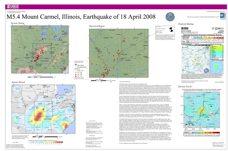
EARTHQUAKES IN THE WABASH VALLEY SEISMIC ZONE
These earthquakes occurred in the Wabash Valley Seismic zone. The
earthquakes in this zone are scattered over a large area of southeastern
Illinois and southwest Indiana. The zone had at least eight prehistoric
earthquakes over the past 20,000 years with estimated magnitudes ranging
from about 6.5 to 7.5, based on geologic evidence. Earthquakes of the
size of the recent quake (Mw 5.2) can produce smaller aftershocks over the
following days. A few might be large enough to be felt. Typically,
earthquakes of this size (Mw 5.2) can cause light damage within a few tens
of miles from the epicenter. Central and eastern US earthquakes generally
shake areas about 10 times as large as those that occur in California. It
is not surprising that this earthquake was felt as far south as Florida.
The Wabash Valley Seismic zone is adjacent to the more seismically active New Madrid seismic zone on the seismic zone's north and west. The recent earthquake is also within the Illinois basin - Ozark dome region that covers parts of Indiana, Kentucky, Illinois, Missouri, and Arkansas and stretches from Indianapolis and St. Louis to Memphis. Moderately frequent earthquakes occur at irregular intervals throughout the region. The largest historical earthquake in the Illinois Basin region (magnitude 5.4) damaged southern Illinois in 1968. Moderately damaging earthquakes strike somewhere in the region each decade or two, and smaller earthquakes are felt about once or twice a year.
Earthquakes in the central and eastern U.S., although less frequent than in the western U.S., are typically felt over a much broader region. East of the Rockies, an earthquake can be felt over an area as much as ten times larger than a similar magnitude earthquake on the west coast. A magnitude 4.0 eastern U.S. earthquake typically can be felt at many places as far as 100 km (60 mi) from where it occurred, and it infrequently causes damage near its source. A magnitude 5.5 eastern U.S. earthquake usually can be felt as far as 500 km (300 mi) from where it occurred, and sometimes causes damage as far away as 40 km (25 mi).
FAULTS
Earthquakes everywhere occur on faults within bedrock, usually miles
deep. Most bedrock in the Illinois basin - Ozark dome region was formed
as several generations of mountains rose and were eroded down again over
the last billion or so years.
At well-studied plate boundaries like the San Andreas fault system in California, scientists can often determine the name of the specific fault that is responsible for an earthquake. In contrast, east of the Rocky Mountains this is rarely the case. The Illinois basin - Ozark dome region is far from the nearest plate boundaries, which are in the center of the Atlantic Ocean, in the Caribbean Sea, and in the Gulf of California. The region is laced with known faults but numerous smaller or deeply buried faults remain undetected. Even the known faults are poorly located at earthquake depths. Accordingly, few earthquakes in the region can be linked to named faults. It is difficult to determine if a known fault is still active and could slip and cause an earthquake. As in most other areas east of the Rockies, the best guide to earthquake hazards in the Illinois basin - Ozark dome region is the earthquakes themselves.
Downloads

Settings
The posters may be downloaded for viewing or for printing on a color
plotter. Adobe PDF (.pdf) format files are provided. Adobe Acrobat 6.0 or
higher is required for viewing the PDF file on a computer monitor and for
printing the PDF map graphic. IMPORTANT: The PDF map graphic was produced
using TrueType fonts; change the following setting to:
Page(Print)Setup<Properties<Layout<Advanced<Graphic<TrueTypeFont<DownloadAsSoftFont
Attention MAC users: If you have problems viewing the pdf files, please download the pdf file and view it in the lastest verion of Adobe Acrobat.
