
Poster of the Loyalty Islands Earthquake of 09 April 2008 - Magnitude 7.3
Tectonic Summary
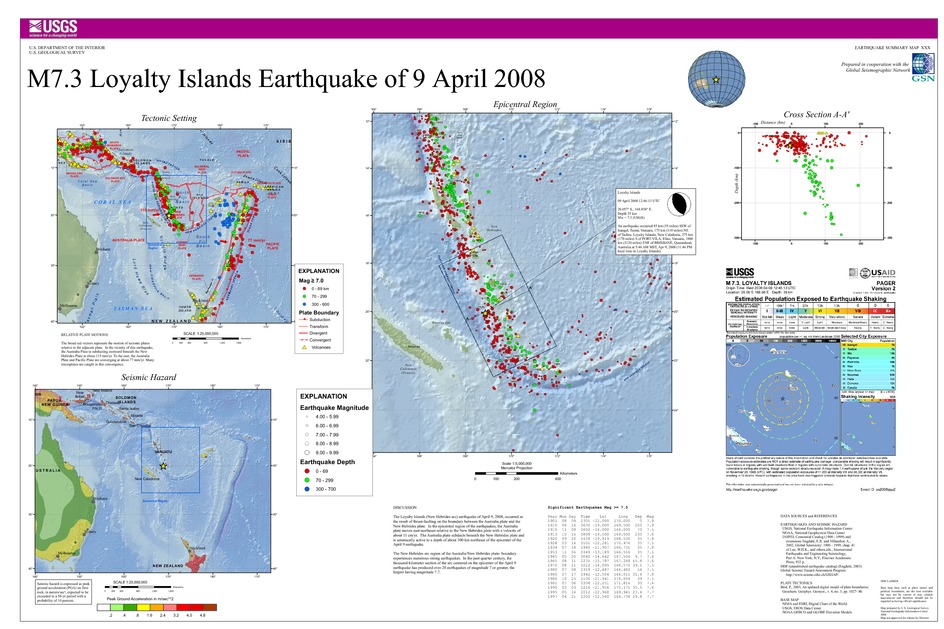
The Loyalty Islands (New Hebrides arc) earthquake of April 9, 2008, occurred as the result of thrust-faulting on the boundary between the Australia plate and the New Hebrides plate. In the epicentral region of the earthquakes, the Australia plate moves east-northeast relative to the New Hebrides plate with a velocity of about 11 cm/yr. The Australia plate subducts beneath the New Hebrides plate and is seismically active to a depth of about 300 km northeast of the epicenter of the April 9 earthquake.
The New Hebrides arc region of the Australia/New Hebrides plate-boundary experiences numerous strong earthquakes. In the past quarter century, the thousand kilometer section of the arc centered on the epicenter of the April 9 earthquake has produced over 20 earthquakes of magnitude 7 or greater, the largest having magnitude 7.7.
Downloads
Settings
The posters may be downloaded for viewing or for printing on a color
plotter. Adobe PDF (.pdf) format files are provided. Adobe Acrobat 6.0 or
higher is required for viewing the PDF file on a computer monitor and for
printing the PDF map graphic. IMPORTANT: The PDF map graphic was produced
using TrueType fonts; change the following setting to:
Page(Print)Setup<Properties<Layout<Advanced<Graphic<TrueTypeFont<DownloadAsSoftFont
Attention MAC users: If you have problems viewing the pdf files, please download the pdf file and view it in the lastest verion of Adobe Acrobat.
