
Poster of the Xinjiang-Xizang Region Earthquake of 20 March 2008 - Magnitude 7.2
Tectonic Summary
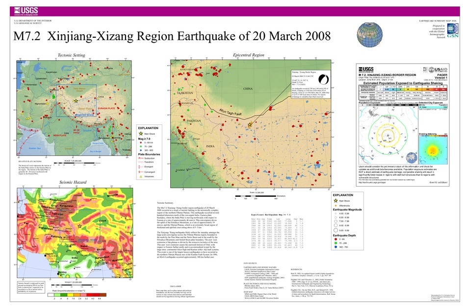
The earthquake occurred as a result of normal faulting in the tectonically complex region of the northern Tibetan Plateau. This earthquake occurred several hundred kilometers north of the convergent India-Eurasia plate boundary, where the Indian Plate is moving northwards with respect to Eurasia at a rate of approximately 46 mm/yr. This convergence drives the uplift of the Himalaya Mountains, at a rate of approximately 10 mm/yr, and the Tibetan Plateau, which is an extremely broad region of thickened and uplifted crust sitting above 4.5-5.0 km.
The uplifted Tibetan Plateau is spreading to the east and, as a result, is an area of east-west extension and eastward crustal motion within a larger region of generally north-south convergence. The Xinjiang-Xizang earthquake likely reflects the interplay amongst these major tectonic forces, dominated in this location by east-west extension. The eastward motion of Tibet, with respect to Eurasia further north, is accommodated in part by the large intra-continental Altyn Tagh and Kunlun strike-slip fault systems. The March 20, 2008 event is one of the largest known historical earthquakes to have occurred in the northern Tibetan Plateau west of the Kunlun Fault System. In 1996, a 6.9Mw earthquake occurred approximately 300 km further west.
Downloads

Settings
The posters may be downloaded for viewing or for printing on a color
plotter. Adobe PDF (.pdf) format files are provided. Adobe Acrobat 6.0 or
higher is required for viewing the PDF file on a computer monitor and for
printing the PDF map graphic. IMPORTANT: The PDF map graphic was produced
using TrueType fonts; change the following setting to:
Page(Print)Setup<Properties<Layout<Advanced<Graphic<TrueTypeFont<DownloadAsSoftFont
Attention MAC users: If you have problems viewing the pdf files, please download the pdf file and view it in the lastest verion of Adobe Acrobat.
