
Poster of the Kuril Islands Earthquakes of 15 November 2006 and 13 January 2007
Tectonic Summary
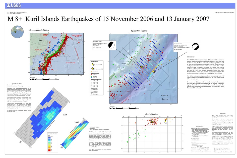
The M 8.3 Kuril Islands earthquake of 15 November 2006 occurred as shallow thrust-faulting on the boundary between the Pacific plate and the Okhotsk plate. The M 8.1 earthquake on 13 January 2006 occurred as steep normal-faulting approximately 95 km ESE of the November earthquake within the outer-rise portion of the Pacific plate. In the region of these earthquake epicenters, the Pacific plate moves northwest with respect to the Okhotsk plate with a velocity of about 90 mm/year. The Pacific plate subducts beneath the Okhotsk plate at the Kuril-Kamchatka Trench and becomes progressively deeper to the northwest, remaining seismically active to a depth of about 680 km.
The 15 November earthquake occurred with maximum slip under 900 cm on a rupture surface 400 km long and 138 km wide dipping about 15° to the northwest.
In contrast, the 13 January 2007 earthquake occurred with maximum slip over 2000 cm, on a rupture surface 200 km long and 35 km wide dipping about 60° to the southeast. This is much steeper, in the opposite direction, on a rupture surface about 10-15% the area of the November 2006 earthquake.
Downloads

Settings
The posters may be downloaded for viewing or for printing on a color
plotter. Adobe PDF (.pdf) format files are provided. Adobe Acrobat 6.0 or
higher is required for viewing the PDF file on a computer monitor and for
printing the PDF map graphic. IMPORTANT: The PDF map graphic was produced
using TrueType fonts; change the following setting to:
Page(Print)Setup<Properties<Layout<Advanced<Graphic<TrueTypeFont<DownloadAsSoftFont
Attention MAC users: If you have problems viewing the pdf files, please download the pdf file and view it in the lastest verion of Adobe Acrobat.
