
Poster of the Andreanof Islands, Aleutian Islands, Alaska Earthquake of 19 December 2007 - Magnitude 7.2
Tectonic Summary
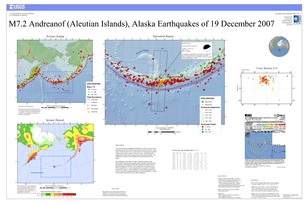
The Aleutian Islands earthquake of December 19, 2007, occurred on the boundary between the North America plate and the Pacific plate. In this region, the Pacific plate moves to the northwest with respect to the North American plate with a velocity of about 72 mm/y. The Pacific plate subducts beneath the North American plate at the Aleutian trench. The earthquake occurred as thrust-faulting on the interface between the plates.
The earthquake of December 19, 2007, ruptured a segment of the Pacific/North America plate boundary that is spatially situated between the segments of the plate boundary that ruptured in the great Aleutian Island earthquakes of March 9, 1957 (magnitude 8.6) and February 4, 1965 (magnitude 8.7). Great earthquakes also occurred in the central Aleutian arc on May 7, 1986 (magnitude 8, about 300 km distant from the site of the 2007 earthquake) and June 10, 1996 (magnitude 7.9, about 150 km distant from the site of the 2007 earthquake)
Downloads
Settings
The posters may be downloaded for viewing or for printing on a color
plotter. Adobe PDF (.pdf) format files are provided. Adobe Acrobat 6.0 or
higher is required for viewing the PDF file on a computer monitor and for
printing the PDF map graphic. IMPORTANT: The PDF map graphic was produced
using TrueType fonts; change the following setting to:
Page(Print)Setup<Properties<Layout<Advanced<Graphic<TrueTypeFont<DownloadAsSoftFont
Attention MAC users: If you have problems viewing the pdf files, please download the pdf file and view it in the lastest verion of Adobe Acrobat.
