
Poster of the Northern Chile Earthquake of 14 November 2007 - Magnitude 7.7
Tectonic Summary
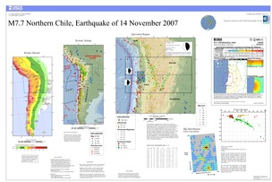
This earthquake resulted from the release of stresses that were generated by the subduction of the oceanic Nazca plate beneath the South American plate. In this region, known as the Peru-Chile subduction zone, ongoing subduction occurs at a rate of about 7.8 cm/year in an east-north-east direction. The subduction process generates numerous earthquakes and volcanism, and actively builds the Andes mountains. Subduction zones produce the biggest earthquakes on the planet. The largest earthquake of the past 100 years, the magnitude 9.5 1960 Chilean earthquake, occurred in the Peru-Chile subduction zone. The 1960 Chilean earthquake ruptured a 900-km long swath along the Chilean coast about 2000 km to south of the 13 June 2005 earthquake.
Downloads
Settings
The posters may be downloaded for viewing or for printing on a color
plotter. Adobe PDF (.pdf) format files are provided. Adobe Acrobat 6.0 or
higher is required for viewing the PDF file on a computer monitor and for
printing the PDF map graphic. IMPORTANT: The PDF map graphic was produced
using TrueType fonts; change the following setting to:
Page(Print)Setup<Properties<Layout<Advanced<Graphic<TrueTypeFont<DownloadAsSoftFont
Attention MAC users: If you have problems viewing the pdf files, please download the pdf file and view it in the lastest verion of Adobe Acrobat.
