
Poster of the Northern Mariana Islands Earthquake of 31 October 2007 - Magnitude 7.2
Tectonic Summary
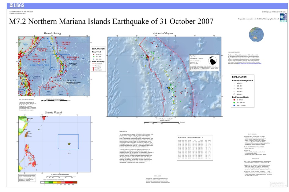
The Mariana Islands earthquake of October 31, 2007, occurred in the inclined seismic zone that marks the position of the subducted Pacific plate beneath the overriding Philippine Sea and Mariana plates. The earthquake represents the release of stress resulting from the distortion of the Pacific plate. Earthquakes, such as this one, that have focal depths between 70 and 300 km are commonly termed "intermediate-depth" earthquakes. "Deep-focus" earthquakes, with focal depths greater than 300 km, also occur in the subducted Pacific plate beneath the Mariana island arc. Earthquakes have been reliably located to depths of about 630 km beneath the Mariana arc.
Although the broad-scale tectonics of the epicentral region are dominated by the subduction of the Pacific plate beneath the Philippine Sea plate, the two plates do not have a mutual boundary at the latitude of the earthquake. Instead, they are separated by a spreading ridge (the Mariana Trough) and the small Mariana plate. The Pacific plate thrusts under the Mariana plate at the Mariana Trench. In this region, the Pacific plate moves to the west with respect to the interior of the Philippine Sea plate with a velocity of about 40 mm/year, and it moves to the west with respect to the Mariana plate with a velocity of about 60 mm/year.
Downloads

Settings
The posters may be downloaded for viewing or for printing on a color
plotter. Adobe PDF (.pdf) format files are provided. Adobe Acrobat 6.0 or
higher is required for viewing the PDF file on a computer monitor and for
printing the PDF map graphic. IMPORTANT: The PDF map graphic was produced
using TrueType fonts; change the following setting to:
Page(Print)Setup<Properties<Layout<Advanced<Graphic<TrueTypeFont<DownloadAsSoftFont
Attention MAC users: If you have problems viewing the pdf files, please download the pdf file and view it in the lastest verion of Adobe Acrobat.
