
Poster of the Southwest of Sumatra, Indonesia Earthquake of 24 October 2007 - Magnitude 6.8
Tectonic Summary
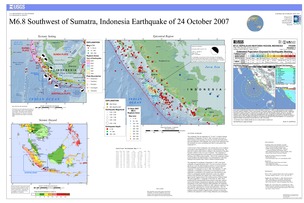
This earthquake, like the magnitude 8.4, 7.9 and 7.1 southern Sumatra earthquakes of September 12 and 13, 2007, occurred as the result of thrust faulting on the boundary between the Australia and Sunda plates. At the location of these earthquakes, the Australia plate moves northeast with respect to the Sunda plate at a velocity of about 60 mm/year. The direction of relative plate motion is oblique to the orientation of the plate boundary offshore of the west coast of Sumatra. The component of plate-motion perpendicular to the boundary is accommodated by thrust faulting on the offshore plate-boundary. Much of the component of plate motion parallel to the plate boundary is accommodated by strike-skip faulting on the Sumatra fault, which is inland on Sumatra proper.
The magnitude 8.4 earthquake of September 12, 2007 is the fourth earthquake of magnitude greater than 7.9 to have occurred in the past decade on or near the plate boundaries offshore of western Sumatra. This earthquake occurred just north of the source region of the magnitude 7.9 earthquake on June 4, 2000. The September 12, 2007 magnitude 7.8 earthquake occurred about 225 km northwest of the magnitude 8.4 earthquake at the northern end of the aftershock zone. These two earthquakes and their aftershocks overlay the southern portion of the estimated 1833 rupture zone, which extends from approximately Eggano Island to the northern portion of Siberut Island. The great magnitude 9.1 earthquake of December 26, 2004, which produced the devastating Indian Ocean tsunami of that date, ruptured much of the boundary separating the India plate and the Burma plate. Immediately to the south of the great 2004 earthquake, the magnitude 8.6 Nias Island earthquake of March 28, 2005, ruptured a segment of the plate boundary separating the Australia and Sunda plates. Since the December 26, 2004 earthquake, much of the Sunda trench between the northern Andaman Islands to Eggano Island, a distance of more than 2,000 km, has ruptured in a series of large subduction zone earthquakes
Downloads
Settings
The posters may be downloaded for viewing or for printing on a color
plotter. Adobe PDF (.pdf) format files are provided. Adobe Acrobat 6.0 or
higher is required for viewing the PDF file on a computer monitor and for
printing the PDF map graphic. IMPORTANT: The PDF map graphic was produced
using TrueType fonts; change the following setting to:
Page(Print)Setup<Properties<Layout<Advanced<Graphic<TrueTypeFont<DownloadAsSoftFont
Attention MAC users: If you have problems viewing the pdf files, please download the pdf file and view it in the lastest verion of Adobe Acrobat.
