
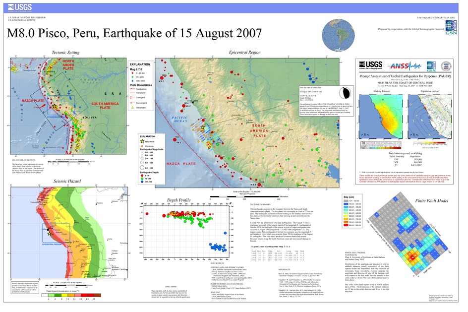
Poster of the Ica, Peru Earthquake of 15 August 2007 - Magnitude 8.0
Tectonic Summary
This earthquake occurred at the boundary between the Nazca and South American tectonic plates. The two plates are converging at a rate of 78 mm per year. The earthquake occurred as thrust-faulting on the interface between the two plates, with the South American plate moving up and seaward over the Nazca plate. Coastal Peru has a history of very large earthquakes. The August 15 shock originated near the source of two earthquakes, both in the magnitude 8 range, that occurred in 1908 and 1974. This earthquake is south of the source of a magnitude 8.1 earthquake that occurred in northern Peru in 1966 and it is north of the magnitude 8.4 earthquake that occurred in 2001 near Arequipa, Peru. The largest earthquake along the coast of Peru is the magnitude 9 that occurred in 1868. The 1868 earthquake produced a tsunami that killed several thousand people along the South American coast and also caused damage in Hawaii.
Downloads
Settings
The posters may be downloaded for viewing or for printing on a color
plotter. Adobe PDF (.pdf) format files are provided. Adobe Acrobat 6.0 or
higher is required for viewing the PDF file on a computer monitor and for
printing the PDF map graphic. IMPORTANT: The PDF map graphic was produced
using TrueType fonts; change the following setting to:
Page(Print)Setup<Properties<Layout<Advanced<Graphic<TrueTypeFont<DownloadAsSoftFont
Attention MAC users: If you have problems viewing the pdf files, please download the pdf file and view it in the lastest verion of Adobe Acrobat.
