
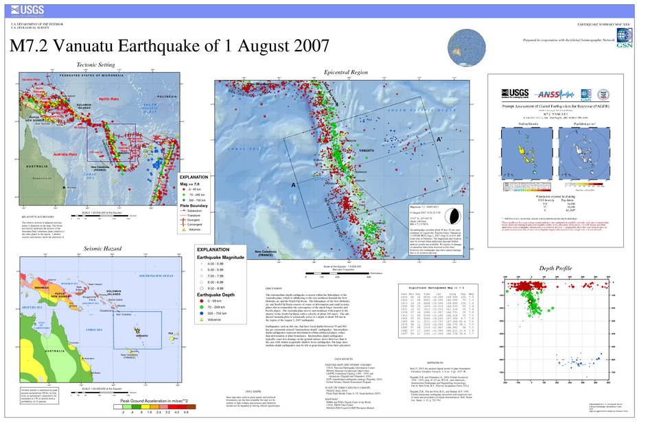
Poster of the Vanuatu Earthquake of 01 August 2007 - Magnitude 7.2
Tectonic Summary
This intermediate-depth earthquake occurred within the lithosphere of the Australia plate, which is subducting to the east-northeast beneath the New Hebrides arc and the North Fiji Basin. The lithosphere of the New Hebrides arc and North Fiji Basin consists of zones of deformation and small tectonic plates that accommodate the convergence of the much larger Australia and Pacific plates. The Australia plate moves east-northeast with respect to the interior of the North Fiji Basin with a velocity of about 100 mm/y. The subducted Australia plate is seismically active to a depth of about 300 km in the region of the August 1, 2007 earthquake.
Earthquakes, such as this one, that have focal-depths between 70 and 300 km are commonly termed intermediate-depth earthquakes. Intermediate-depth earthquakes represent deformation within subducted plates, rather than deformation at plate boundaries. Intermediate-depth earthquakes typically cause less damage on the ground surface above their foci than is the case with similar magnitude shallow-focus earthquakes, but large intermediate-depth earthquakes may be felt at great distance from their epicenters.
Downloads
Settings
The posters may be downloaded for viewing or for printing on a color
plotter. Adobe PDF (.pdf) format files are provided. Adobe Acrobat 6.0 or
higher is required for viewing the PDF file on a computer monitor and for
printing the PDF map graphic. IMPORTANT: The PDF map graphic was produced
using TrueType fonts; change the following setting to:
Page(Print)Setup<Properties<Layout<Advanced<Graphic<TrueTypeFont<DownloadAsSoftFont
Attention MAC users: If you have problems viewing the pdf files, please download the pdf file and view it in the lastest verion of Adobe Acrobat.
