
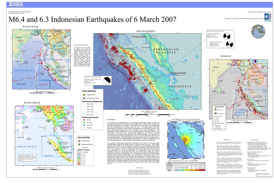
Poster of the Southern Sumatra, Indonesia Earthquakes of 06 March 2007 - Magnitudes 6.4 and 6.3
Tectonic Summary
The locations and focal-mechanisms of the Sumatra earthquakes of March 6, 2007, are consistent with these shocks occurring on the Sumatran fault, a 1900 km-long strike-slip fault that extends the length of the island. At the latitude of the earthquake, the average long-term rate of displacement on the fault is about 20 mm/yr. The exact position of the 2007 earthquakes with respect to earlier historic earthquakes on the Sumatran fault will not be known until detailed studies have been conducted of the recent earthquakes. Two earthquakes having magnitudes of 7.2 and 7.5, respectively, occurred within seven hours of each other on June 8-9, 1943, with epicenters assigned to the section of the fault immediately to the southeast of the epicenters of the 2007 earthquakes. The magnitude 7.5 shock was among the largest earthquakes to have occurred on the Sumatran fault since the late nineteenth century. Two earthquakes that occurred within three hours of each other on June 28, 1926, which have been assigned magnitudes of 6 1/2 and 6 3/4 respectively, have been assigned epicenters virtually identical to the epicenters of the 2007 earthquakes.
The tectonics of west-central Sumatra are dominated by the motion of the Australia plate northward with respect to the Sunda plate at a velocity of about 50 mm/yr. The principal plate boundary is taken to be the axis of the Sunda trench, but significant plate-boundary deformation occurs in a zone that extends hundreds of kilometers inland from the Sunda trench. The component of motion of relative plate motion that is perpendicular to the trend of the plate-boundary is mostly accommodated by underthrusting along the Sumatra subduction zone, which dips eastward from the Sunda trench and is seismically active to depths of over 200 km in west-central Java. The Sumatra subduction zone has historically produced great thrust-fault earthquakes. The component of relative plate motion that is parallel to the plate-boundary is substantially accommodated by strike-slip faulting on the Sumatra fault, which is about 300 km inland of the Sunda trench. The part of the Sunda plate that lies to the west of the Sumatra fault and east of the principal plate boundary at the Sunda trench is sometimes called the "forearc sliver" of the Sunda plate, being distinguished from the rest of the Sunda plate because of its relative motion with respect to the plate's interior.
Downloads
Settings
The posters may be downloaded for viewing or for printing on a color
plotter. Adobe PDF (.pdf) format files are provided. Adobe Acrobat 6.0 or
higher is required for viewing the PDF file on a computer monitor and for
printing the PDF map graphic. IMPORTANT: The PDF map graphic was produced
using TrueType fonts; change the following setting to:
Page(Print)Setup<Properties<Layout<Advanced<Graphic<TrueTypeFont<DownloadAsSoftFont
Attention MAC users: If you have problems viewing the pdf files, please download the pdf file and view it in the lastest verion of Adobe Acrobat.
