
Poster of the Kuril Islands Earthquake of 13 January 2007 - Magnitude 8.1
Tectonic Summary
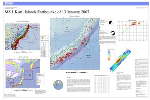
The Kuril Islands earthquake of 15 November 2006, occurred as thrust-faulting on the boundary between the Pacific plate and the Okhotsk plate. The M8.1 earthquake on 13 January 2006 occurred as normal-faulting approximately 95 km ESE of the November earthquake within the outer-rise portion of the Pacific plate. In the region of these earthquake epicenters, the Pacific plate moves northwest with respect to the Okhotsk plate with a velocity of about 90 mm/year. The Pacific plate subducts beneath the Okhotsk plate at the Kuril-Kamchatka Trench and becomes progressively deeper to the northwest, remaining seismically active to a depth of about 680 km. The 15 November earthquake is the largest earthquake to have occurred in the central Kuril Islands since the early 20th century. A central Kuril Islands earthquake in 1915 is estimated to have had a magnitude of about 8. The central Kuril Islands commonly experiences one or more shocks of magnitude 6 or greater in a decade. To the southwest, the southern Kuril Islands chain experienced a magnitude 8.5 earthquake in 1963. To the northeast, a magnitude 9 earthquake occurred offshore of Kamchatka in 1952.
Downloads
Settings
The posters may be downloaded for viewing or for printing on a color
plotter. Adobe PDF (.pdf) format files are provided. Adobe Acrobat 6.0 or
higher is required for viewing the PDF file on a computer monitor and for
printing the PDF map graphic. IMPORTANT: The PDF map graphic was produced
using TrueType fonts; change the following setting to:
Page(Print)Setup<Properties<Layout<Advanced<Graphic<TrueTypeFont<DownloadAsSoftFont
Attention MAC users: If you have problems viewing the pdf files, please download the pdf file and view it in the lastest verion of Adobe Acrobat.
