
Poster of the South Sandwich Islands, Scotia Sea, Earthquake of 20 August 2006 - Magnitude 7.0
Tectonic Summary
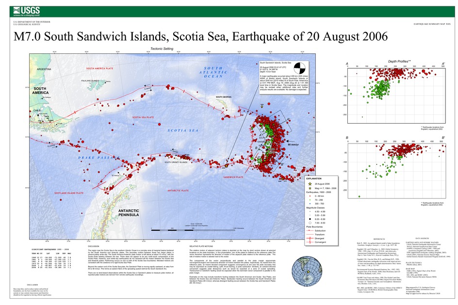
The region near the Scotia Sea in the southern Atlantic Ocean is a complex area of marginal basins bordered by the South America and Antarctic plates. The boundary motion between these two larger plates is predominately strike-slip. The South America-Antarctic plate motion is left lateral at about 15 mm/yr, with the Scotia Plate twisting between the two. There does not appear to be any north-south compression of the Scotia Plate. However, pure strike-slip earthquakes do not represent all the motion between the Scotia Sea and Antarctic plates. Partitioning occurs on one or both of the Scotia Sea boundaries. Modeled motions are consistent with the existence of a rigid Scotia Sea Plate.
Beyond the eastern end of the Scotia Sea plate, the Sandwich Plate is moving rapidly eastward, at rates from 65 to 90 mm/yr. This forms an eastern flank of the spreading system behind the South Sandwich Arc.
There are no land-based observations within the Scotia Sea or Sandwich plates to measure plate motion; all reported plate motions are derived from remote earthquake recordings.
Downloads
Settings
The posters may be downloaded for viewing or for printing on a color
plotter. Adobe PDF (.pdf) format files are provided. Adobe Acrobat 6.0 or
higher is required for viewing the PDF file on a computer monitor and for
printing the PDF map graphic. IMPORTANT: The PDF map graphic was produced
using TrueType fonts; change the following setting to:
Page(Print)Setup<Properties<Layout<Advanced<Graphic<TrueTypeFont<DownloadAsSoftFont
Attention MAC users: If you have problems viewing the pdf files, please download the pdf file and view it in the lastest verion of Adobe Acrobat.
