
Poster of the Java, Indonesia Earthquake of 26 May 2006 - Magnitude 6.3
Tectonic Summary
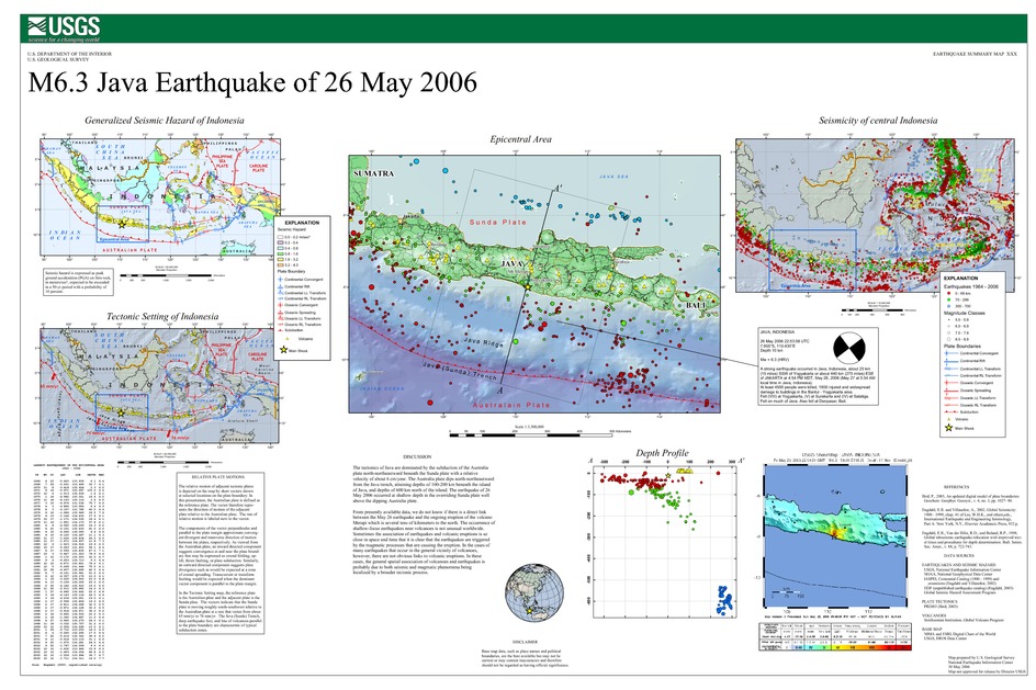
The tectonics of Java are dominated by the subduction of the Australia plate north-northeastward beneath the Sunda plate with a relative velocity of about 6 cm/year. The Australia plate dips north-northeastward from the Java trench, attaining depths of 100-200 km beneath the island of Java, and depths of 600 km north of the island. The earthquake of 26 May 2006 occurred at shallow depth in the overriding Sunda plate well above the dipping Australia plate.
From presently available data, we do not know if there is a direct link between the May 26 earthquake and the ongoing eruption of the volcano Merapi which is several tens of kilometers to the north. The occurrence of shallow-focus earthquakes near volcanoes is not unusual worldwide. Sometimes the association of earthquakes and volcanic eruptions is so close in space and time that it is clear that the earthquakes are triggered by the magmatic processes that are causing the eruption. In the cases of many earthquakes that occur in the general vicinity of volcanoes, however, there are not obvious links to volcanic eruptions. In these cases, the general spatial association of volcanoes and earthquakes is probably due to both seismic and magmatic phenomena being localized by a broader tectonic process.
Downloads

Settings
The posters may be downloaded for viewing or for printing on a color
plotter. Adobe PDF (.pdf) format files are provided. Adobe Acrobat 6.0 or
higher is required for viewing the PDF file on a computer monitor and for
printing the PDF map graphic. IMPORTANT: The PDF map graphic was produced
using TrueType fonts; change the following setting to:
Page(Print)Setup<Properties<Layout<Advanced<Graphic<TrueTypeFont<DownloadAsSoftFont
Attention MAC users: If you have problems viewing the pdf files, please download the pdf file and view it in the lastest verion of Adobe Acrobat.
