
Poster of the Zarand, Iran Earthquake of 22 February 2005 - Magnitude 6.4
Tectonic Summary
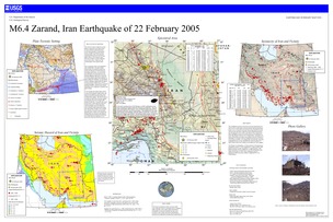
This earthquake occurred as the result of stresses generated by the motion of the Arabian plate northward against the Eurasian plate at a rate of 2 to 3 cm/yr (about one inch per year). Deformation of the Earth's crust in response to the plate motion takes place in a broad zone that spans the entire width of Iran and extends into Turkmenstan. Earthquakes occur as the result of both reverse faulting and strike-slip faulting within the zone of deformation. Preliminary analysis of the pattern of seismic-wave radiation from the February 22 earthquake is consistent with the earthquake having been caused by reverse slip on an ENE- or E-striking fault. The fault that caused the earthquake has not yet been identified; the shock took place in a region within which east-trending reverse-faults have been mapped.
The February 22 earthquake is 125 km northwest of the destructive earthquakes of June 11, 1981 (magnitude 6.6, approximately 3,000 deaths) and July 28, 1981 (magnitude 7.3, approximately 1,500 deaths) and about 250 km northwest of the devastating Bam earthquake of December 26, 2003 (magnitude 6.6, over 30,000 deaths).
Downloads
Settings
The posters may be downloaded for viewing or for printing on a color
plotter. Adobe PDF (.pdf) format files are provided. Adobe Acrobat 6.0 or
higher is required for viewing the PDF file on a computer monitor and for
printing the PDF map graphic. IMPORTANT: The PDF map graphic was produced
using TrueType fonts; change the following setting to:
Page(Print)Setup<Properties<Layout<Advanced<Graphic<TrueTypeFont<DownloadAsSoftFont
Attention MAC users: If you have problems viewing the pdf files, please download the pdf file and view it in the lastest verion of Adobe Acrobat.
